walk

  • Bishopstone and the Ridgeway

    Bishop Stone walk

    Over the years I have walked many stretches of The Ridgeway.  One day I might do the whole thing in a go, but in reality picking it off bit by bit is a rather nice way of doing it.  This walk is 10.12km or 6.2miles and involves a steady climb up to the Ridgeway through some lovely narrow valleys and then another steady descent to Ashbury for a return via Idstone.


    Walk Facts:

    Distance: 10.12km / 6.2 miles
    Total Climb: 145m
    Walked: Early October 2018

    The route:

    10.1 km, 02:35:15

    Meet at the car park of the Royal oak in Bishop Stone. From the front of the pub turn left and walk through the village, at the crossroads go straight over following the footpath well signposted towards the Ridgeway. 

    If you’re not in a hurry right by the primary school at your find a lovely little duckpond.

    The footpath continues between the back gardens and is a delightful little alleyway with lovely planting and thatched cottages. Short way along the pathway divides take the left turn coming up some steps it’s well signposted towards the Ridgeway.

    You will pop out onto the road where you turn right following the road itself for short way.

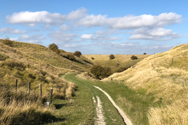
    You will soon find another signpost taking you off to the right down a track way it’s signposted Ridgeway circular walk. You then continue down the track way along the beautiful valley in the direction of the Ridgeway.

    The trackway soon becomes a pathway which opens up into the valley via a gate continue following the obvious footpath through the fields and enjoy the scenery.

    The valley opens out and you get to see you can take in the stepped fields that climb up towards the Ridgeway.  Go throug several gates and then follow the valley which veers to the left - don’t go over the tempting old style to the right.

    Has the valley narrows it turns to the right go through the gate brackets it was open for me) and then continue the climb is still to come.

    At the top of the valley it opens up and not too far away your find the Ridgeway. Turn left. It’s signposted Ridgeway circular walk. Don’t follow the bridleway that heads off to the right.

    The route now follows the Ridgeway for over 3 km. It is in affect the highway for hikers carved out of the chalk running across the top of the hills. Watch out before mountain bikers and horses.

    Past Ridgeway farm and it’s crossroads. Take a deep breath if the pigs are out!

    Watch out for views of Ashdown house off to the right and the cost down into the Vale of White horse to the left including the Watchfield wind turbines Faringdon folly and Shrivenham

    The Ridgeway slowly will sounds a bit more of a footpath rather than a roadway. You’ll soon find a signpost for the spec Valley and the permissive footpath which could take you on a shorter route back to Bishop Stone, continue on the Ridgeway past them.

    Another half a kilometre long and your find another set of crossroads and farm buildings. You could choose to turn left and it’s on the hill to Idstone. There is also some drinking water here. For this route though continue straight on the Ridgeway.

    Next object of interest is a signpost to the Rosen Crown Inn, you could turn left here and cut the route a little short. But my plan is to continue on following the Ridgeway little further.

    Cross the Ashbury Hill Road and it’s carpark sticking with the Ridgeway a little further. Look out for the Ashbury folly. Not that I can find it.

    500 m along before you cross a long tree line your find a signpost on the footpath to the left that takes you across some open field take a left it’s time to go downhill.

    As you cross the field path does a little dog like before you get to a friends and go through a gate into another field.

    The pathway follows the fence to the left down to the V of the valley and then follows the V all way Down to the village.

    At the bottom of the valley there is a gate, another field, then some allotments and the pathway runs to the left of those.

    Cross the road. The footpath picks up a little bit to the right the other side and continues across some overgrown common land.

    The path continues into a thicket, with quite a drop to the right into a little Valley. Careful.

    You come out at a little pond and then a hard surface to footpath goes to the left taking you back into the village.

    The path brings you out onto the main road cross straight over and follow Chapel Lane.

    Where Chapel Lane turns left with its pretty thatched cottages continue straight on on to Berrycroft.

    Staying in a straight line take the trackway that goes past Kings close East cottage. The pathway continues to the right of the cottages and then a hedged field (going to go into the field!) The alleyway brings you to a kissing gate and once more out into open countryside.

    Continue in a straight line in the direction back to Idstone and Bishop Stone.

    At the end of the field descend down to Lidl trackway cross that pick up the footpath the other side which again crosses fields.

    The footpath descends down to a bridge over the stream which looks really rather rickety! Then returns to the field just outside idstone where we then cross Featherbed Lane. you go through some farm buildings and a gate and have picked up the Ridgeway circular path signs again.

    Cross the style and your back into fields in open countryside again.

    Pathway follows to the right of the next field. Turning a little to the north

    Eventually you go through another gate in the corner of the field cross the bridge through another gate and continue this time to the right of the hedge Until you find another gate ( fighting the nettles ) into a tree lined Lane. Which takes you back to Bishop Stone.

    At the end of the lane cross the road and find a style into a field which is a permissive path further into the village. Cross the next stile or maybe go through the gate if you can. Turn to the right and then take the first left to follow along the narrow lane, so be careful, it will take you back to the pub

  • Bledlow and the Chilterns

    Bledlow Walk

    If you fancy a bit of up and down, this is a lovely walk along the escarpment of the Chiltern Hills.  It starts at The Lions of Bledlow pub climbs a short section of the Ridgeway entering the Bledlow Great Wood.  There are some lovely hill top views before descending just short of Chinnor and returning via the Ridgeway to Bledlow.  


    Walk Facts:

    Distance: 6.17km / 3.83 miles
    Total Climb: 162m
    Walked: September 2017

    The route:

    This walk starts from The Lions of Bledlow pub which has a large car park at the back.  Expect a bit of a climb, but as with all routes around Oxfordshire, it's no mountain!

    6.1 km, 01:58:28

    Route description:

    It's been a while since this route has been walked.  I will update with a detailed description when I can.


  • Brill and Oakley

    Brill and Oakley

    Just over the Oxfordshire border, but surrounded by the county and with great views in to it, this walk starts at the top of the hill in Brill and loops down to Oakley and climbing back via the historic windmill.


    Walk Facts:

    Distance: 10.57km / 6.5 miles
    Total Climb: 225m
    Walked: April 2019

    The route:

    10.6 km, 02:57:03

    Route description:

    This route starts from The Pointer on Church Street.  There is also a pub called The Pheasant which is on Windmill Street, you can follow the last few instructions to get to the start point from there.  Head up to the church and walk along The Green.  You will find the footpath begins to the right after a wide grassy stretch of the road and leads off south in to open fields and immediately you see some lovely views.

    Keep Brill House to your right hand side and head into a larger field through the gate. The pathway then turns to the left through some pretty muddy churnings and some animal pens and continues in a straight line east eventually veering to the right and beginning a descent from the top of the hill.

    Continue through a double set of gates (although one seems to be no longer be used) and continue across the fields with the distant Chiltern Park farm ahead and just to the right.

    Go through the kissing gate. You can see the large Ardley incinerator off to the north in the distance. The footpath continues to the left hand side of the farm.

    You'll find another kissing gate just after the farm buildings and then continue down the hill heading towards the copse of woodland directly ahead. The next gate is right in the middle of the trees.

    Go through the copse, across the rickety bridge, back through another gate and then directly south-east across the next field.  Cross over the rickety style through the hedge and then turn immediately right. Follow the hedge south-west, keeping it on your right.

    The path opens up into the next field where continue in a straight line.  If you can't see the path (there was no sign of it when I walked the route) use the two trees as markers. In the middle of the field turn to the right and look north-west. You should see a style at the end of the line of trees on the fields edge. If the field is overgrown you might actually want to retrace your steps and then follow the edge of the field to the next style.  The path follows the side of the field north westerly.

    Cross the trackway and then begin to climb again. Stay in a straight line heading pretty much north-west. It's then across the field, through the little gate and then in to the next field through the gap. If you are wondering where the footpath is, just head to that gap. Cross the next field aiming for the corner with Parkpale Farm in.  Pick up the farm track and follow it to the road.

    Turn left south west and walk along the Thame Road for a little way and you will see the footpath head off between some gardens on the right.

    At the end of the footpath is a little bench and a style - cross it into the field. Continue west across the field and go through the large gate and then turn left following the side of the field downhill towards Leatherslade Farm.

    About halfway down the pathway go through the gates and it continues in a thin long stretch of woodland. It’s pretty overgrown in places and there are plenty of nettles, so long trousers are probably wise. It’s also really churned up in places so expect either to get muddy or possibly a twisted ankle!

    Once you have circumnavigated Leatherslade Farm (which is where the Great Train robbers of 1963 hid out) join the farm track continuing downhill looking for a footpath off to the right. Go through the kissing gate and then head west across three fields in the direction of Little London.

    The gate out of the final field and in to the village is about a third of the way from the left hand side along the far hedge. Cross the road onto the footpath and turn right looking for a footpath off to the left. You’ll find it by the postbox. The path is down a long little lane and a little unmade road. Pass beyond the last house (called Blackfriars) and the footpath continues - in fact its a bridleway.  

    Just after you pass under a significant low hanging branch the footpath peels off to the left hand side.  You can either follow that or stick with the bridleway as they both join up a little further along. I chose to go along the footpath as it seems a lot less churned up - although it did have a pretty impressive style to get over!

    The footpath crosses a style and returns to the bridleway, take it left (west). If you stick with the bridleway also keep to the left with it. Don’t be tempted to head right or east towards Nashway farm.

    At the crossroads you’ll find lots of options. turn right and then immediately right there is a style where the footpath picks up again (the bridleway runs parallel but really you want to be on the footpath.) You can see up the hill to Brill and it’s windmill. We are headed back that way in the end!

    The footpath continues in the field following the hedge to the left basically heading north then Northwest.  Just after where the bridleway turns left the footpath also turns left across a style into the field heading north west.

    At the corner of the next field your find a very rundown style which is pretty broken, so take care crossing it into a little patch of woodland. Vier to the right and find the Span Green track. Follow this and it’s rutted muddy road as far as the hamlet of Touchbridge.

    Here Span Green joins the road heading north east. A short way along you will see a pathway split off to the right (after a farm track). This is the Bernwood Jubilee Way and we are going to follow it back to Brill. It passes through a kissing gate then some shrubland with nice views up to the Windmill, past some burnt out remains of something and across some fields.

    Where you see the style is abandoned in the middle of nowhere about halfway along the hedge, cross into that field and then keep that hedge to the right and find the style out of the field.  

    You are now back in Brill.

    Turn left to see the Windmill and to get to The Pheasant pub.   To get back to the church follow Bernwood Jubilee Way to the right and then it turns North West again to bring you up to the village centre.

    It’s just a short walk further to the church.

    My Flickr photos from the route.

    Route planned by Kate Brown and walked by Phil Mercer-Kelly.

  • Duns Tew Walks

    Duns Tew and Middle Barton Walk

    A lovely circular walk through the rolling landscape of North Oxfordshire centred around the village of Duns Tew.  There are two versions, a longer one that takes in Middle Barton and a shorter version


    Walk Facts:

    Distance: 11.35km / 7.05 miles
    Total Climb: 149m
    Walked: October 2017

    The route:

    The longer walk actually starts from The Fox Inn pub in Middle Barton, but you can also start it from The White Horse in Duns Tew. There is a fair amount of up and down on this route as you make your way around a river valley.  

    11.4 km, 02:40:23

    Route description:

    It's been a while since this route has been walked.  I will update with a detailed description when I can.


    Duns Tew shorter walk

    A lovely circular walk through the rolling landscape of North Oxfordshire.  There are two versions, a longer one that takes in Middle Barton and a shorter version. 

    Walk Facts:

    Distance: 9.75km / 6.05 miles
    Walked: October 2017

    The route:

    The shorter walk starts from The White Horse in Duns Tew and misses out on Middle Barton. There is a fair amount of up and down on this route as you make your way around a river valley.  

    9.8 km, 01:59:07

    Route description:

    It's been a while since this route has been walked.  I will update with a detailed description when I can.


  • Hailey and Ipsden Walk (Chilterns)

    Hailey and Ipsden (Chiltern Hills)

    A great walk in the Chiltern Hills.  Starting from the King William IV pub and taking in parts of The Chiltern Way Southern Extension.  The route passes the former home of Ian Fleming (creator of 007) and Black Adder star Rowan Atkinson.  There is a fair amount of up and down on this route, but nothing over the top.


    Walk Facts:

    Distance: 9.67km / 6 miles
    Total Climb: 343m
    Walked: March 2019

    The route:

    9.7 km, 02:39:33

    Route description:

    This walk starts from The King William IV in the tiny village of Hailey near Wallingford which has some lovely view and is great for a summers day sitting out the front.  From the front of the pub turn left on to the Chiltern Way Southern Extension (CWSE) and east and continue along the track way as it makes a stead climb.  The CWSE turns off to the right after some houses, ignore and continue along the track for another 2km passing through Bixmore Wood.  Take the signposted path on the right, just before a house and well before you get to Homer Farm.  This will take you down past Fludger's Wood.  

    You will descend on a path alongside the ultra modern starkly white house at Handsmooth.  This was built by star of Black Adder and Mr Bean Rowan Atkinson.  It caused a lot of controversy at the time and does stand out rather.  I like it though.  He must get some great views.  Turn right and continue past his front gate and Handsmooth Farm.  

    Once you get to Wellplace Farm turn left in to the stables and through various signed gates that climb you up the hill.  The route stays in the fields until the very top where once you go through a gate it gets a little confusing.  Turn right and then follow the fence line until you climb in to the woods.  Someone has helpfully put a map up for those who are lost!  Turn right and begin to go down hill.  There is a significant ditch with a road the other side of it. Keep to the right hand bank, the path is pretty undefined but winds its way through the trees eventually bringing you out on to the road and Warrens Chase.  Turn left (south) to once again pick up the CWSE.  A bit more climbing here up Berins Hill.  Stay with the CWSE as it continues along Braziers Lane.  Eventually the CWSE leaves Braziers Lane and continues south, stay on Braziers Lane heading West passing some cottages and eventually Braziers Park itself.  This once belonged to the Fleming family and was where Ian Fleming, the author of 007 James Bond was born.  Other interesting things happened here involving Mick Jagger and Marianne Faithful, so it's worth a quick read up before heading on.  

    Turn right after the big house and head north along the road towards Ipsden.  It's a busy road at times, so take care.  For a short section you can take a footpath in the woods to the right of the lane.  You might even see the leprechaun doors!  Cross Garsons Lane and continue along the path as far as the village of Ipsden.  Just before the little wooden hall you will see a footpath turning right.  Take this and take the steady climb all the way to the top where you will once again pick up the CWSE.  This time take it north.  With a short dog leg you climb through a field and will see the pub at the top to the left.  When you get to the top of the field you rejoin a track, turn left and a little bit further along you are back at the pub.  Well done. 

    My Flickr photos from the route.

    Route planned by Alan Mutton.


  • Horspath and Shotover Country Park

    Oxford: Horspath and Shotover

    There are some lovely walks a short distance from Oxford.  This one takes in Shotover Country Park, the ancient London road and the villages of Wheatley and Littleworth.  There is even a windmill.


    Walk Facts:

    Distance: 9.44km / 5.86 miles
    Total Climb: 204m
    Walked: March 2015

    The route:

    This walk starts from The Queens Head in Horspath but it passes close to other pubs in Littleworth and Wheatley, so you could chose to start from there.  It heads through Oxford City Council's Shotover Country Park with its plentiful dog walkers, carpets of bluebells and occasional Dungeons and Dragons fans.  From there is follows the old road to London and then down past Shotover House, Wheatley and then back up the hill via the Wheatley Windmill.

    9.4 km, 02:41:26

    Route description:

    It's been a while since this route has been walked.  I will update with a detailed description when I can.

    My Flickr photos from the route.


  • Letcombe Regis Walk

    Letcombe Regis Walk

    A lovely walk in the Vale of White Horse from the lovely little village of Letcombe Regis, through Letcombe Bassett and then up to the Ridgeway coming back via the ancient Segsbury iron age fort.


    Walk Facts:

    Distance: 8.3 km / 5.16 miles
    Total Climb: 161m
    Walked: Late October 2019

    The route:

    8.8 km, 02:08:54


    This walk starts from The Greyhound pub in Letcombe Regis.

    Head south from the pub and pass the church to the left hand side towards the Richmond Villages shop.  Follow the road to the right of the shop and you will find an alleyway.  This takes you down to the Letcombe Brook. Cross the bridge and out onto the road.

    Turn left (south) and then follow past recreation ground, a small burial-ground and follow the wall.  Take the road on the left  opposite the entrance to Blandys Farm. A short way along, the road becomes a footpath and crosses back over the Letcombe Brooke.  Go through the gate and join the Letcombe Valley and a well-established pathway.  It brings you out into a nature reserve, follow the grass pathway to the left (south east) not the gravel one to the right (south west).

    At the top go through the gate and take  the bridlewaypath to the right.  You very quickly come to another gate with a footpath that actually leads off to the right just before it.

    It’s a lovely walk along the top a little valley cut out by the Letcombe Brook.  It brings you to the village of Letcombe Bassett, 

    Here you have a couple of options…

    Letcombe Basset Option One

    The most direct route is to turn in to Basset Road and then head west on to Holborn Hill until you get to a playground take a left turn out into the fields.

    Letcombe Basset Option Two

    An alternative longer, but I think prettier way is to turn left and go up Rectory Lane (basically continuing south).  Pass the pretty cottages and under the wooden footbridge.  The road turns to grass and then you’ll find a style at the top on the right.

    Cross the field while stopping to enjoy the views of the beautiful thatched barn and across the valley. The path ducks back into the woods and comes quickly down onto a road, turn right (north) and return into the village.

    Turn left after the old rectory and into Fosters Lane passing the tiny chapel. 

    At the end go through the kissing gate and take the pathway across the field to the right. Turn right at the side gate set on its own away from the fence and follow fence line north back down towards the village.  Through gate, pass some farm buildings and out onto the road. Turn left follow the (Holborn Hill) road a little way and just after the playground take a left turn out into the fields.

    This is a permissive path so make sure you stick to the route you or you might get shot!  

    You’ll see the pathway continues up the hill in the distance to the south east.  It is well signposted.  The path leads to a corner of fencing turn to the left and follow the fence line continuing uphill south east towards the hedge in the distance.

    Once up to the corner of the fence line follow the little track around to the right and then all the way to the top.  Don’t forget to stop and take in the views, especially of the Devils Punchbowl and Childrey Warren.

    At the top you will find the Ridgeway and once again are on public rights of way.  You are going to turn left (east) and follow this ancient path for quite a while (2.2km). Hopefully you have a nice clear day, because the views are absolutely stunning.

    About 900m along you cross Gramps Hill, just keep going.  The path can get very muddy at times, so be prepared to do some puddle jumping.  Continue past Smith Hill which has a little carpark and a signpost back down to Letcome Bassett.

    As you come to Segsbury Farm your time on the Ridgeway is over for this walk.  Now take the road to the north.  Here begins the descent back to the Letcombes. 

    First though the trackway cuts straight through the ancient Segsbury Fort.  You can chose to follow the road, but you can also walk the old mound of the fort.  Again this is a permissive pathway so make sure you follow all the instructions at the entrance to the fort.

    Continue down the hill following the road all the way into the village it’s a steady descent on a hard road surface, so nothing too much to struggle about and not too much traffic either.

    When you enter Letcombe Regis turn in to South Street which takes you back to the church and then the pub on Main Street.  There is also a cut through way which heads between the houses from Anvil Lane, bringing you out at Post Office Lane.


  • Lewknor Walk

    Lewknor Walk

    A walk with a steady climb up the Chilterns escarpment to take in the view of Oxfordshire you see at the beginning of the Vicar of Dibley.  Just a short distance from junction 7 of the M40 with regular coach connections to Oxford and beyond.


    Walk Facts:

    Distance: 9.55 km / 5.93 miles
    Total Climb: 222m
    Walked: Late November 2019

    The route:

    9.6 km, 02:46:33


    I've not had a chance to write up the route details for this walk.  This one starts from The Leathern Bottle in Lewknor.  You can also start the walk from the northbound M40 bus stop.  There are regular buses to Oxford, London, Heathrow and Gatwick airports.  This route has a steady climb up to the top of the Chilterns escarpment and Cowleaze Wood.  From there is descends back down to join the Ridgeway and then return back to Lewknor.  The ups and downs are not as bad as you might think and its worth it for the views.

  • Radley and Kennington Walk

    The River Thames near Radley

    Radley walk

    This is a nice mainly flat walk that takes in some of the Thames Path north from Radley up to Sandford Lock and Kennington from there it loops back via Radley woods. There is a bridge over a railway with lots of steps and a bit of road and pavement walking.  To make up for that the Thames Path was extremely muddy when I walked it in late January 2019.


    Walk Facts:

    Distance: 10.25km / 6.36 miles
    Total Climb: 65m
    Walked: Early January 2019

    The route:

    Options:  You can start in a few locations around the route, all with a pub handy.  The track recorded starts at the village hall in Kennington and The Tandem pub opposite.  We used the route for a BBC Radio Oxford walk which started from the Bowyer Arms in Radley, which has parking.  A third option is the Kings Arms at Sandford Lock, which has a pay and display car park.

    10.2 km, 02:22:58

    Route description:

    These notes follow the recorded track from Kennington Village Hall and Tandem Pub, any notes relevant for the other options are at the end.  

    Head south on Kennington Road taking a left turn in to Bagley Wood Road.  Follow this along for quite a distance, going straight over at St Swithun's Road.  Take the track that runs to the right hand side of the continuation of Bagley Wood Road.  This will bring you to a recreation ground.  Continue across the playing fields and Memorial Field with its strange tufts then down the hill.  You make a short right turn in to Radley Large Wood to follow the pathway back up the hill.  There are lots of paths through the woods, I followed the western boundary of the wood.  This brings you out at Sugworth Lane which you cross.  Then over the fields following the path and back in to Radley Little Wood.  Follow the path around the western and then southern boundary and it brings you out at a permissive path around the grounds of Radley College.  You continue in to the ground and the path turns left and takes you down to rejoin Kennington Road.

    Follow the Kennington Road south towards Radley, this picks up the Oxfordshire Green Belt Way.  Turn left in to Church Road past the cute Radley Church and its bizarre hedge, carry on down in to the village.  

    Turn left in to Uxbridge Square (this is where the Radley route joins in) and cross the railway.  Follow the road east passing through Lower Radley, the Thames Path is signed here, follow it right and then left again towards the Radley College Boat House.  

    When you reach the river turn north and follow the Thames Path through the grounds of the boat club, crossing its little footbridge and out across the fields.  The route is very well trodden from here, following the river bank.  It has a few sections that are falling in to the river and there was rubbish left by fisherman which is pretty depressing.  The path gets squeezed between some woods and the river and when walked in January was extremely muddy (as you can see in the Flickr album) so care is required.  The pathway eventually brings you out at a car park Sandford Lane.  

    Options:  From here you have an option, the tracked route follows the main stream of the river crossing the bridge to the right, but you could continue straight on to the Sandford Lock Hydro Scheme.  The path rejoins the tracked route after the weir.  

    Cross the river stream staying on the Thames Path.  This takes you to Sanford Lock, stay on the western side of the lock (this is where the Sandford Lock option for the walk joins) and head off through the fields north of Sandford Lock.

    You will cross a bridge to take you on to another little island, at the north end of the second bridge you follow the main path on, this is where the option to see the hydro scheme rejoins the route.  Through a gate and out over fields, just pick the driest looking path, after a little while you will see a path peel off to the left and head towards a towering footbridge over the railway.  Over the bride and then you find yourself behind the Tandem Pub, the village hall is opposite.  

    Well done, you are back at the beginning.  Unless you walked the two option routes, in which case click here to go back to the top

    Notes:

    Radley Walk - If you are starting from Radley, walk north along Foxborough Road for a short way up from the pub to the turn for Uxbridge Square and pick up the route described above. Click here to jump to the relevant section of the route description

    Sanford Lock Walk - If you are starting from the Kings Arms in Sandford then you don't have far to go.  Just walk out on to the river bank and lock and cross over to other other side.  The Thames Path resumes (as does the tracked route) from the north end. Click here to jump to the relevant section of the route description.

  • The Best Walks

    My favourite walks

    I've done plenty of walks, and seen lots of lovely sights.  These are my favourites so far.


  • Water Eaton Walk

    Water Eaton Walk

    A nice flat walk from Oxford Parkway station to Cutteslowe Park with its little railway and gardens and the historic Water Eaton Manor.


    Walk Facts:

    Distance: 9.43 km / 5.86 miles
    Total Climb: just gentle climbs, the route is almost flat.
    Walked: September 2021.

    The route:

    9.4 km, n/a


    Getting there:

    Parking costs around £2 (at time of walking) and you can use the Ringo App to pay, or head in to the station building.
    There is a cafe and toilets at the station, and at the Bus terminal.
    Regular busses go in to Oxford and Kidlington, trains run to Oxford, Bicester and London Marylebone.

    The details:

    Start at water Eaton Park and ride or Oxford Parkway car park. 

    From the front of the railway station take the pathway that climbs up to the main road and a bus stop, then head south (towards Oxford) crossing over the traffic lights for the entrance to the park-and-ride and then continuing until you get to the entrance to Water Eaton Farm. Turn left (east) and take the the bridleway, which is a nice concrete farm road.

    After around a kilometre, when the concrete road turns to the left you’ll find a signpost marking out a footpath to the right to Cutteslowe Park follow it heading south. 

    The path does a dog-leg south east and then turns back south-ish.

    After a short while the track turns to the east again together with the hedge, but you want to stay with the footpath which continues straight on across the field from that bend.

    Through the gap in the hedge and straight across the next long field.

    Through another hedgerow and a little bridge and cross a corner of a field to another hedgerow and another bridge which takes you into Cutteslowe Park.

    The park has many paths and things to see, it’s worth spending a little time and wandering around.  You will arrive at the sports fields but further south there is a walk through some woods that takes you clockwise around the a large pond, a nursery and cafe, some gardens and even a little train ride. When you have had your fill, head back to the sports fields and where you came in.

    More information on Cutteslowe Park here.

    Our return journey covers some of the ground we’ve already walked, so out of Cutteslowe Park the same way you came in and then head back across the field passing through a hedgerow. 

    About halfway across the next much larger field you’re going to turn right following a footpath which is barely visible. When I walked this there was a ghost of a tractor trail just before you get to a Telegraph poll (not the big power cable though) it takes you east towards a little cut through the hedge, which should help you find the way.

    Once through I followed the left hand edge of the field to pick up a track again.

    Follow the track through another hedge, across another short field again and through another hedge all continuing to follow the track.

    At the end of the next field the trackway turns to the left and you’ll see a footpath continue straight on with a little bridge over the stream, cross it (you should see Water Eaton Manor in the distance).

    Once again it’s hard to find the path, the OS says it goes straight across the field, but it looks like that hasn’t been walked in a while. If you keep to the left hand hedge you will eventually pick up the new path.  Look out for a lone tree as a nice way marker.

    Once you’ve crossed that field you pick up a pathway beside the hedge so turn to the right (east) and head towards the river.

    The map says you should go as far as the bridge before turning almost back on yourself to cross following the Oxfordshire greenbelt way into the grounds of the old manner. But now that pathway actually picks up on your left hand side as you get to the end of the hedge row. So maybe go and have a quick look at the river take some nice pictures and then come back to the hedgerow and cross the field heading north you’ll see a nice white marker and a style in the hedge ahead.

    Over the style and into the grounds of water Eaton Manor. Watch out for the cattle!

    Water Eaton manor house was built for Sir Edward Frere in 1586 but reduced in size at a later date. The Gothic Revival architect GF Bodley restored the house in 1890 and made it his home. It is now a Grade II listed building.  You can read more about it on Wikipedia. Click here.

    After you have passed the lovely house and buildings the pathway cuts between the wall and some buildings (one with a garage door!) to pass the chapel and then head north across the field following a very clear path.

    Once you reach the fence with the signpost on the gate go through the gate going left and then back onto the track following that South again.

    Pass the front drive to Water Eaton Manor and then continue along the concrete road back to the main road retracing your steps back to Oxford Parkway Station.

    PMK